Lyons Canyon Ranch Project Draft Environmental Impact Report and Appendices
Tentative Tract Map No. 53653 / Conditional Use Permit RCUP200500088
Created 30 October 2006; Updated 26 January 2008
David Magney Environmental Consulting (DMEC) prepared environmental assessment documents for the Lyons Canyon Ranch development project for Los Angeles County Regional Planning on behalf of D.R. Horton - Western Pacific [Housing] Series. The Draft Environmental Impact Report (DEIR) was made public on 25 September 2006, and is available here in electronic format for viewing online or downloading. The public comment period closes on 8 November 2006. A public hearing before the Los Angeles County Regional Planning Commission was held on 15 November 2006 in the Regional Planning Commission Hearing Room, 320 Temple Street, Los Angeles, California 90012. The Final EIR will be available for review in early 2008, date yet to be determined.
All reports (except CEQA documents) copyrighted by David Magney Environmental Consulting 2005 and 2006, unless otherwise indicated. The DEIR and associated appendices are provided below. Do to the very large file sizes of the DEIR and appendices, the DEIR, and some appendices were divided into smaller pieces in an attempt to make them more accessible. All documents are in PDF format unless otherwise indicated.
Links to Lyons Canyon Ranch Documents on DMEC's Website
Los Angeles County Regional Planning's EIR Notice of Completion Documents
DEIR Notice of Completion (806 KB)
Draft EIR Sections
DEIR Title and Table of Contents (341 KB)
DEIR Executing Summary [Section 1] (341 KB)
DEIR Introductin and Purpose [Section 2](113 KB)
DEIR Project Description [Section 3](4,099 KB)
DEIR Cumulative Analysis [Section 4] (792 KB)
DEIR Environmental Analysis [Section 5] (31,736 KB)
Section 5, Impact Analysis, subsections - these are included in the large file listed above but are divided into smaller files for easier downloading.
DEIR Geology, Soils, & Seismicity [Section 5.1] (1,503 KB)
DEIR Hydrology & Drainage [Section 5.2] (1,611 KB)
DEIR Hazards [Section 5.3] (723 KB)
DEIR Noise [Section 5.4] (335 KB)
DEIR Air Quality [Section 5.5] (245 KB)
DEIR Biological Resources [Section 5.6] (17,369 KB)
DEIR Cultural Resources [Section 5.7] (1,028 KB)
DEIR Mineral Resources [Section 5.8] (104 KB)
DEIR Aesthitic-Visual Resources [Section 5.9] (6,422 KB)
DEIR Traffic [Section 5.10] (1,203 KB)
DEIR Water & Wastewater [Section 5.11] (545 KB)
DEIR Schools & Education [Section 5.12] (122 KB)
DEIR Fire Services [Section 5.13] (132 KB)
DEIR Sheriff Services [Section 5.14] (123 KB)
DEIR Solid Waste [Section 5.15] (94 KB)
DEIR Electricity [Section 5.16] (80 KB)
DEIR Natural Gas [Section 5.17] (119 KB)
DEIR Library Services [Section 5.18] (113 KB)
DEIR Parks & Recreation [Section 5.19] (755 KB)
DEIR Land Use [Section 5.20] (731 KB)
DEIR Alternatives [Section 6] (1,624 KB)
DEIR Longterm Implications [Section 7] (156 KB)
DEIR Significant Unavoidable Environmental Effects [Section 8] (61 KB)
DEIR Effects Found Not Significant [Section 9] (60 KB)
DEIR Organization & Persons Consulted [Section 10] (51 KB)
DEIR Bibliography [Section 11] (81 KB)
DEIR Mitigation Monitoring Program [Section 12] (78 KB)
DEIR Appendices
A - CEQA Initial Study (545 KB)
A - Notice of Preparation (7,703 KB)
B - NOP Comment Letters (6,629 KB)
C - Preliminary Title Report (149 KB)
D - Traffic Impact Study (955 KB)
E - Air Quality Impact Assessment (1,067 KB)
F - Noise Impact Assessment (838 KB)
G - Biota Report [entire report](39,316 KB) - For easier downloading, the Biota Report is divided into small sections below.
G - Biota Report Title & Table of Contents (191 KB)
G - Biota Report Project Description (3,027 KB)
G - Biota Report Setting Section (2,440 KB)
G - Biota Report General Biota Survey (1,489 KB)
G - Biota Report Special-Status Biological Resources (787 KB)
G - Biota Report Project Impacts (2,237 KB)
G - Biota Report Mitigation Measures (433 KB)
G - Biota Report SEA Design Compatibility (123 KB)
G - Biota Report Monitoring Program (179 KB)
G - Biota Report Citations & Acknolwedgements (267 KB)
G - Biota Report Appendix A (30,208 KB)
G - Biota Report Appendix B (29,122 KB)
G - Biota Report Appendix C (239 KB)
G - Biota Report Appendix D (162 KB)
G - Biota Report Appendix Quad Sheet & Site Plan (25,770 KB)
H - Oak Tree Report (129 KB)
H - Oak Tree Report Attachment 1 (27 KB)
H - Oak Tree Report Attachment 2 (139 KB)
H - Oak Tree Report Attachment 3 (443,054 KB)
H - Oak Tree Report Attachment 4 (887 KB)
I - Hydrology & Drainage Study [Whole report] (12,534 KB)
I - Hydrology & Drainage Study [1st half] (5,943 KB)
I - Hydrology & Drainage Study [2nd half] (6,606 KB)
J - Cultural Resources Assessment (5,065 KB)
K - Geotechnical Investigation (4,698 KB)
L - Phase I Environmental Assessment (7,376 KB)
M - Water Supply Study (302 KB)
N - Sewer Area Study (4,077 KB)
O - Wetland Delineation [entire report] (57,225 KB)
O - Wetland Delineation [Title & Table of Contents] (1,632 KB)
O - Wetland Delineation [Section 2] (1,823 KB)
O - Wetland Delineation [Section 3] (904 KB)
O - Wetland Delineation [Section 4 on] (5,404 KB)
O - Wetland Delineation [Appendix A-1] (4,896 KB)
O - Wetland Delineation [Appendix A-2] (5,289 KB)
O - Wetland Delineation [Appendix A-3] (5,773 KB)
O - Wetland Delineation [Appendix A-4] (5,304 KB)
O - Wetland Delineation [Appendix A-5] (5,008 KB)
O - Wetland Delineation [Appendix A-6] (5,682 KB)
O - Wetland Delineation [Appendix A-7] (3,712 KB)
O - Wetland Delineation [Appendix A-8] (3,800 KB)
O - Wetland Delineation [Appendix A-9] (3,849 KB)
O - Wetland Delineation [Appendix A-10] (2,702 KB)
O - Wetland Delineation [Appendix B-1] (8,531 KB)
O - Wetland Delineation [Appendix B-2] (815 KB JPEG)
O - Wetland Delineation [Appendix B-2] (815 KB JPEG)
O - Wetland Delineation [Appendix B-3] (261 KB JPEG)
O - Wetland Delineation [Appendix B-4] (412 KB JPEG)
O - Wetland Delineation [Appendix B-5] (436 KB JPEG)
O - Wetland Delineation [Appendix B-6] (472 KB JPEG)
O - Wetland Delineation [Appendix B-7] (476 KB JPEG)
O - Wetland Delineation [Appendix B-8] (487 KB JPEG)
O - Wetland Delineation [Appendix B-9] (471 KB JPEG)
O - Wetland Delineation [Appendix B-10] (490 KB JPEG)
O - Wetland Delineation [Appendix B-11] (486 KB JPEG)
O - Wetland Delineation [Appendix C] (784 KB)
P - School Mitigation & Fire Station Agreements (299 KB)
For problems with this web site, contact DMEC at 805/646-6045, ask for David Magney.
For questions about the DEIR, public hearing, or other project-related CEQA issues, contact Mr. Rudy Silvas, Los Angeles County Department of Regional Planning, Impact Analysis Section, Room 1348, 320 West Temple Street, Los Angeles, California 90012. Mr. Silvas' phone number is 213/974-6461. Information is also available at the Los Angeles County Dept. of Regional Planning web site.
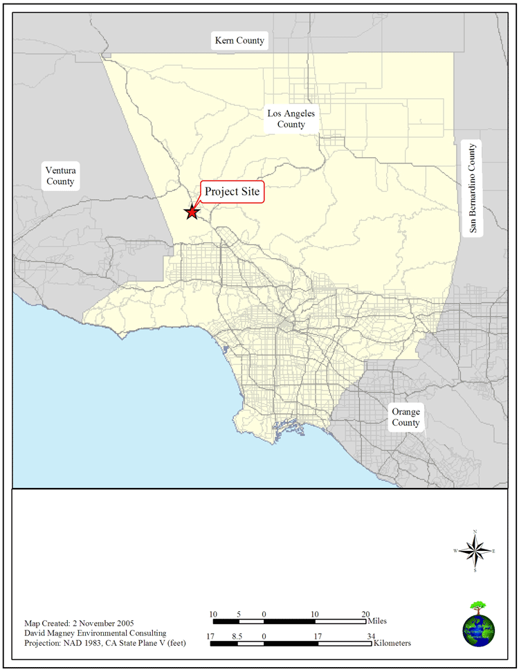
General Map of Lyons Canyon Ranch
Counter Stats

family cars Counter
DMEC Home
DMEC Reports
![O - Wetland Delineation [Appendix B-2]](../Client_Reports/LyonsCynRanch/DEIR/Appendices/O_WetlandDelineation-AppendixB-2.jpg)
![O - Wetland Delineation [Appendix B-3]](../Client_Reports/LyonsCynRanch/DEIR/Appendices/O_WetlandDelineation-AppendixB-3.jpg)
![O - Wetland Delineation [Appendix B-4]](../Client_Reports/LyonsCynRanch/DEIR/Appendices/O_WetlandDelineation-AppendixB-4.jpg)
![O - Wetland Delineation [Appendix B-5]](../Client_Reports/LyonsCynRanch/DEIR/Appendices/O_WetlandDelineation-AppendixB-5.jpg)
![O - Wetland Delineation [Appendix B-6]](../Client_Reports/LyonsCynRanch/DEIR/Appendices/O_WetlandDelineation-AppendixB-6.jpg)
![O - Wetland Delineation [Appendix B-7]](../Client_Reports/LyonsCynRanch/DEIR/Appendices/O_WetlandDelineation-AppendixB-7.jpg)
![O - Wetland Delineation [Appendix B-8]](../Client_Reports/LyonsCynRanch/DEIR/Appendices/O_WetlandDelineation-AppendixB-8.jpg)
![O - Wetland Delineation [Appendix B-9]](../Client_Reports/LyonsCynRanch/DEIR/Appendices/O_WetlandDelineation-AppendixB-9.jpg)
![O - Wetland Delineation [Appendix B-10]](../Client_Reports/LyonsCynRanch/DEIR/Appendices/O_WetlandDelineation-AppendixB-10.jpg)
![O - Wetland Delineation [Appendix B-11]](../Client_Reports/LyonsCynRanch/DEIR/Appendices/O_WetlandDelineation-AppendixB-11.jpg)