| David Magney Environmental Consulting |
|
Oxnard General Plan Reviews |
|
|
Home |
2009Oxnard is revising/updating it citywide General Plan (2030) and is proposing a Specific Plan for the Ormond Beach area. David Magney Environmental Consulting (DMEC) reviewed both plans and their respective Environmental Impact Reports (EIRs). Each is discussed below, with links to Oxnard's environmental documents and DMEC's comment letters. General Plan 2030Oxnard is currently updating its General Plan (General Plan 2030) with a draft plan out for public review in early 2009. David Magney Environmental Consulting (DMEC) was hired by the Environmental Defense Center to critically review the draft 2030 General Plan and associated draft Environmental Impact Report (DEIR) for the plan. As a result of those reviews, DMEC compiled and developed various data about Oxnard that is made available (published) on this web site. DMEC focused its review on biological resources and issues related to Oxnard as a sustainable, liveable community. A major focus of the review centered on Oxnard's parks, highlighting its lack of natural open space parks. Of the 37 parks occurring within the city limits, only three (3) have natural open space and the largest of the three requires an entrance fee (McGrath State Beach), and all three are on the beach, a relatively long distance from most of the city's neighborhoods. Figure 1, Map of Oxnard Parks and Drainages, illustrates where the various types of parks are distributed in Oxnard. The greatest percentage of Oxnard parks are dedicated/focused on active sports. Oxnard's second largest park is a golf course, which has a very narrow focus (golfing) that precludes or prohibits other activities typically associated with parks. Figure 1 also shows the locations, extent, and types of drainages within the city. These drainages are important as they have great potential to provide natural open space (linear) parks that provide aesthetic and mental and physical health benefits to city residents, particularily children, as well as serving many wetland functions that also benefit humans and the environment. Figure 1. Map of Oxnard Parks and Drainages 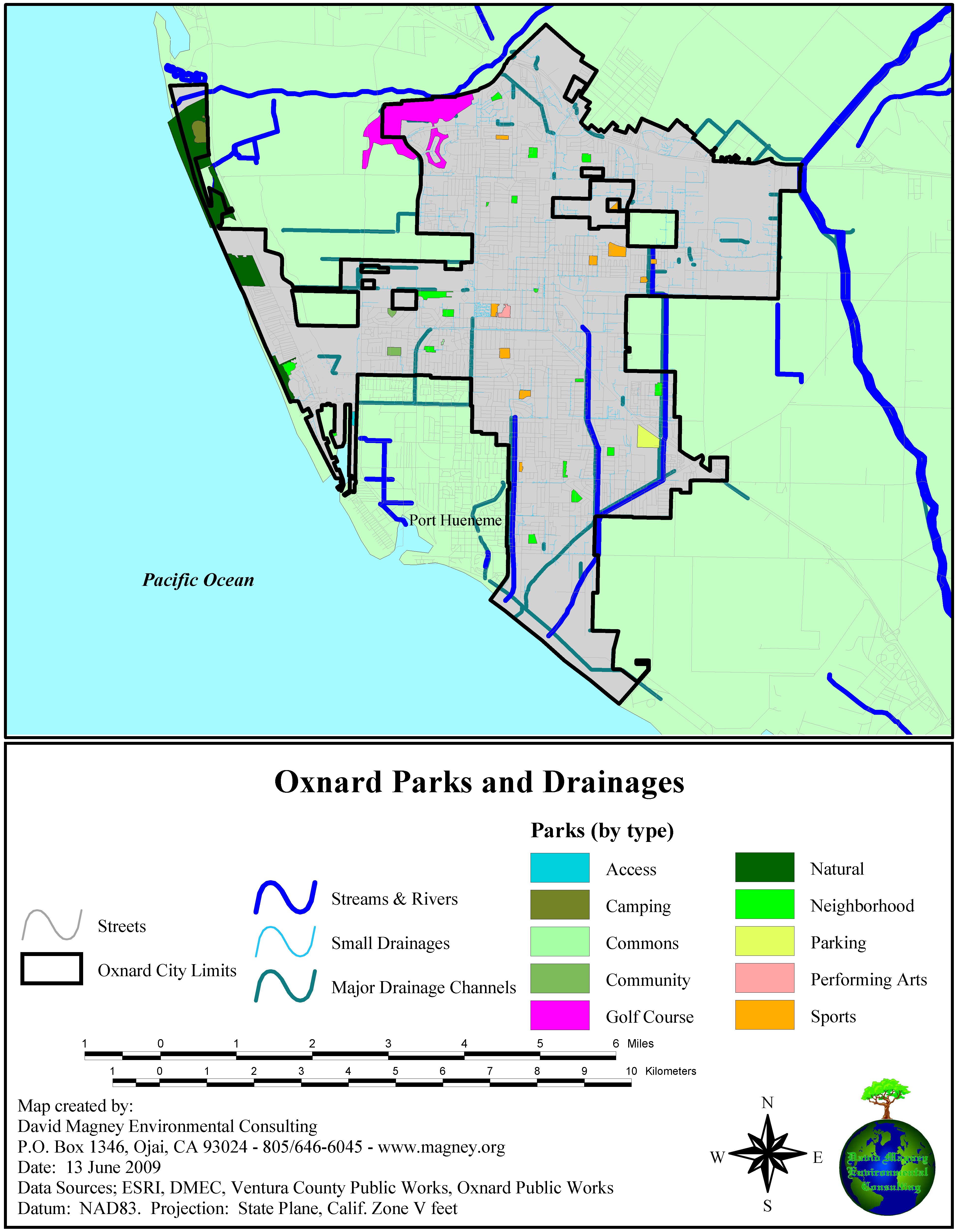
Click on the map to see a high-quality JPEG version. Oxnard's proposed 2030 General Plan claims to have a vision of creating a sustainable community that provides a high quality environment for Oxnard citizens and visitors. This is true in many ways; however, it fails in many ways to accually solve a number of basic problems Oxnard must deal with, including: high crime, rising sea levels, loss of agricultural resources, loss of biological resources, water quality, endangered species and habitats, to name a few. These issues are identified and discussed in greater detail in DMEC's comment letters on the draft 2030 General Plan and on the DEIR. 2008Ormond Beach Specific PlanIn mid-2008, Oxnard recirculated its Draft EIR (RDEIR) for the Ormond Beach Specific Plan Area. DMEC was hired to review and comment on the DEIR, which it had done previously in 2005. The RDEIR basically ignored the comments submitted on the original DEIR, and no additional information on biological resources was gathered or presented. Ormond Beach is extremely important biologically due to the presence there of the Ormond Beach wetlands, which are much reduced in size from their original extent prior to the early 1900s. Ormond Beach has been the focus of several wetland restoration planning efforts, starting in the early 1980s by McClelland Engineers (who later became Fugro West, Inc.), Jones & Stokes Associates (managed by David Magney) on behalf of the City through a grant from the California State Coastal Conservancy (Coastal Conservancy) in the mid-1990s, focusing on Southern California Edison's property on South Ormond Beach, and currently by the Coastal Conservancy for a larger area including all of Ormond Beach. The RDEIR for the Ormond Beach Specific Plan Area was little changed from its 2005 version, which DMEC found to be entirely inadequate in describing and assessing impacts to biological resources. DMEC's comment letter on the RDEIR can be read here, dated 22 September 2008. The City is scheduled to release the Final EIR on the RDEIR in late November/early December 2009. Figure 2, Map of Ormond Beach Wildlife Habitat, illustrates where the natural habitats in the vicinity of Ormond Beach occurs in relation to the Ormond Beach Specific Plan Area. The southern portion of the Ormond Beach Specific Plan Area is currently part of a wetland and upland habitat restoration plan by the Coastal Conservancy and Oxnard's development plans would preclude much of what the Coastal Conservancy is planning. Figure 2. Map of Ormond Beach 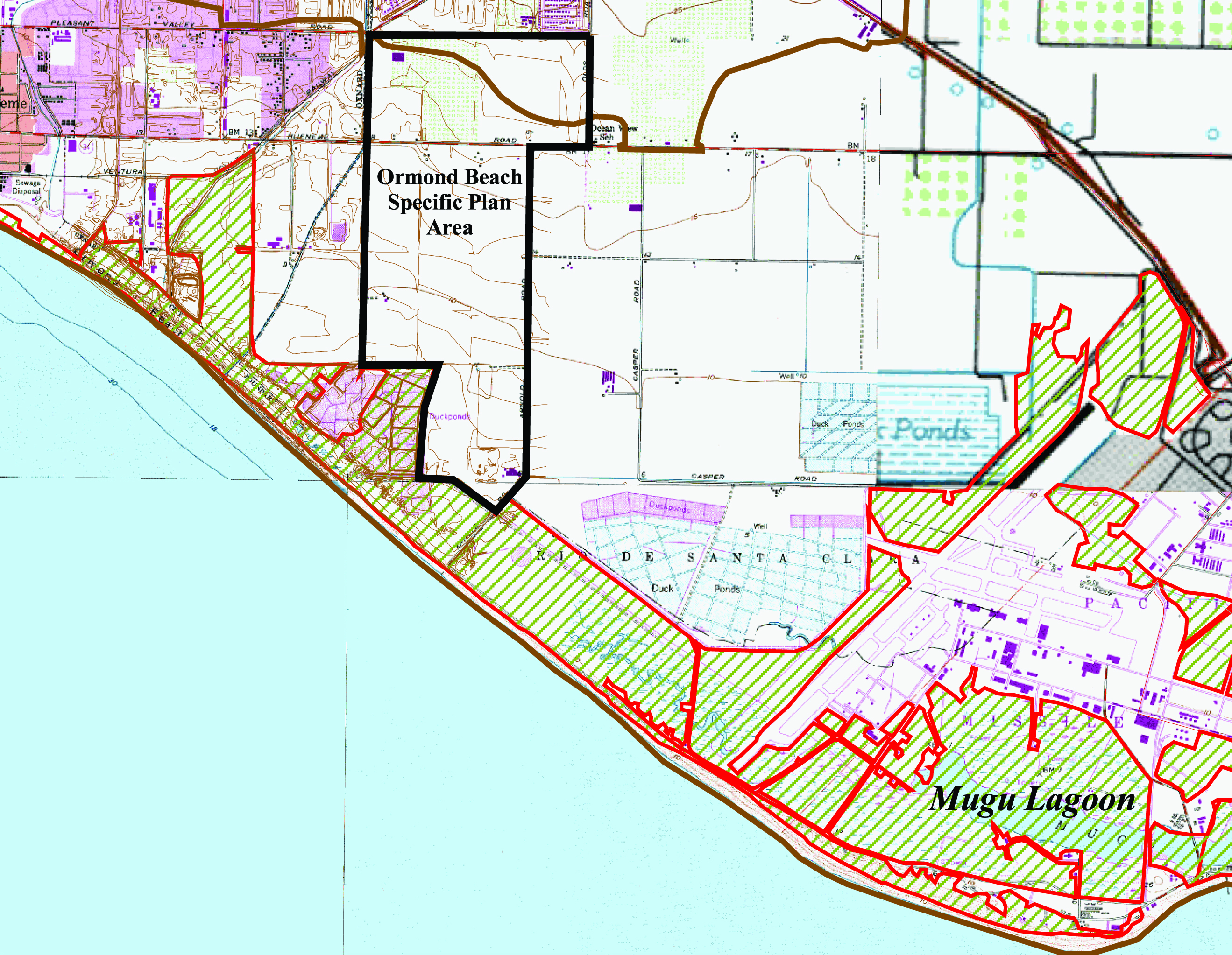
Click on the map to see a high-quality JPEG version. |
|
|
Qualifications & Staff |
|
|
Client List |
|
|
Projects |
|
|
Reports |
|
|
Presentations |
|
|
Contact Us |
Mission Statement:
To provide quality environmental consulting
services with integrity that protect and enhance
the human and natural environment.
