Channel Islands Chapter
 Wildfires, Vegetation, and Homes
Wildfires, Natural Vegetation, and Homes
By David MagneyYou all remember the wildfires of October 2003 and other years. They can be very scary for homeowners who live next to natural vegetation that is prone to burn easily. It is interesting though, how peoples perceptions can be influenced by ignorance or misinformation, such as when the news anchor labels a burned area of chaparral a disaster, showing scenes of scorched hillsides. The fact is, natural vegetation in southern California is able to cope very well to periodic, but infrequent fires. It is humans that do not cope so well, and we too often put our fears, as truly real as they are, onto natural ecosystems.
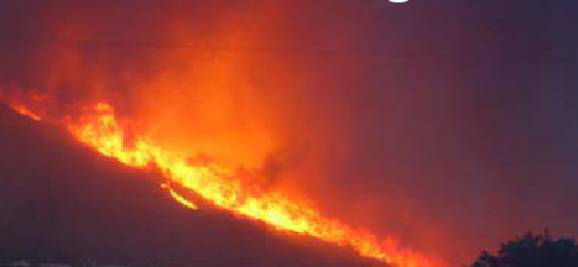
This picture of one of the October 2003 fires in San Diego County was clipped from a photo in a presentation by Dr. Jon Keeley of the USGS.
Colonists to southern California early recognized that water quality was dependent on a healthy watershed, which meant that the native vegetation growing on our mountains and hillsides was providing an invaluable function in maintaining water quality and water quantity for downstream areas. When the natural vegetation is removed, for any reason, there is a significant increase in surface runoff, mudslides, sedimentation of streams, and reduced water percolation into the local aquifers. This realization was the foundation of the Forest Preserve system (the precursor to the Forest Service) established by President Theodore Roosevelt in the late 1890s. In fact, the Pine Mountain and Zaca Lake Forest Reserve was the first reserve established anywhere in the United States, specifically to protect the watersheds supporting Ojai (then called Nordhoff), San Buenaventura, Santa Barbara, and other communities. The boundaries and names changed over the years, and finally evolved into the Los Padres National Forest (in 1936 or 1938). Other Preserves were established in Los Angeles County, and elsewhere.
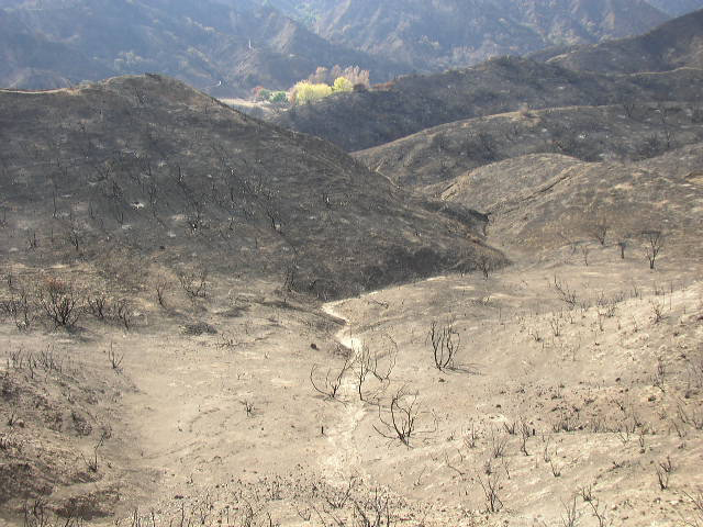
Tributary to Towsley Canyon at the eastern end of the Santa Susana Mountains just southwest of Newhall, burned in October 2003. This area was dominated by Chamise Chaparral, view southward. ©David Magney 2003.
Firefighting was a major focus of these federal reserves, and subsequent incarnations. The mantra has almost always been to suppress any and all wildfires. Frankly, based on extensive research by a number of very talented ecologists and fire specialists, such as Dr. Jon Keeley, now with the U.S. Geologic Survey, we have a much better understanding of the history and ecological effects of natural wildfires and vegetation response, and how fire suppression has worked and not worked.
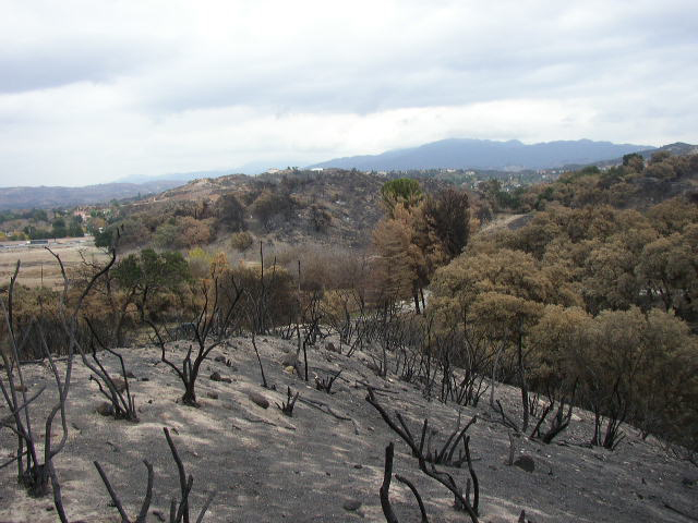
Lyon Canyon at the eastern end of the Santa Susana Mountains just southwest of Newhall, burned in October 2003 (immediately south of Stevenson Ranch, which did not burn at all). This area was dominated by Chamise Chaparral with Coast Live Oak Forest/Woodland dominating the lower slopes and canyons,, view eastward. This is the property that the Dukes of Hazard was filmed on. The chaparral is resprouting well, and many of the Coast Live Oak trees are recovering too. ©David Magney 2003.
Jon Keeley and C.J. Fotheringham presented some very interesting data in 2004 on the effects of fire fighting efforts over the last 100 years in southern California, focusing on shrubland wildfires, the type of wildfire we face in Ventura and Santa Barbara Counties. Their findings are summarized below.
One of the problems revealed by their study is that fire fighters have been treating forests and shrublands the same in their efforts to manage and prevent wildfires; however, they are very different. A prescription for forests (vegetation dominated by trees) is not appropriate for shrublands such as Coastal Sage Scrub and Chaparral. They behave very differently when burning. The fire suppression policies have resulted in fire exclusion, when such goals jeopardize the health of the natural vegetation, which follows with threats and damage to human structures and lives.
Money spent suppressing and fighting wildfires has increased dramatically every decade over the past 100-plus years; however, the number of acres burned has remained relatively stable: lots of acres of natural vegetation burn every year. If the goal of fire fighters is to reduce the area burned, clearly spending more taxpayer dollars has failed to reduce the acreage that does burn.
Most wildfires now are started by arsonists or by accident by humans, ironically often when they are clearing vegetation around their homes, as required by the fire departments. Prior to the population explosion and people building their homes in shrubland habitats, most fires were started by lightning strikes, which is rare in southern California, except in the higher mountains.
One of the concepts strongly implemented by wildland fire fighters is the desire to create defensible space between combustible natural vegetation and human structures. These come in a variety of forms, including clear zones around all homes, fuel breaks along ridges, and a mosaic of different-aged vegetation. The Ventura County Fire Department requires homeowners to clear natural vegetation 100 feet around their homes, and if they dont, the Fire Department will hire someone to do it for them and send the bill to the homeowner.
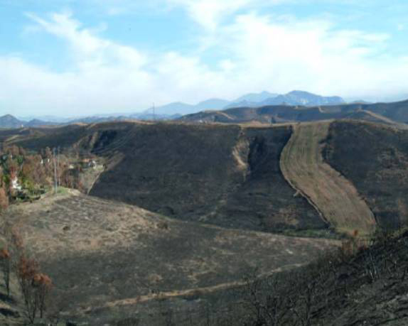
This photo shows a firebreak (right center) and a brush clearance zone (left center, near the houses) in an area of chaparral that burned in October 2003 (courtesy Jon Keeley).
The fires of October 2003 very clearly taught us that having fuelbreaks, multi-aged vegetation mosaics, and brush-clear zones around our homes does not necessarily prevent homes from catching fire; not when Santa Ana winds are fanning the flames and sending embers thousands of feet, including across 8-lane freeways. Basically, there is no such thing as defensible space, there is no such thing as a wide enough fuelbreak when the flames are fed by these hot and strong winds. Those houses that did not burn were those that took care to reduce or eliminate combustible fuels immediately next to them. Those with shake roofs went up in flames.
The practice of prescribed or controlled burning of shrublands was an interesting idea; however, this practice does nothing to stem the spread of wildfires spread by the Santa Ana winds, and the data show that most of the devastating fires in southern California are indeed such fires. Keeley and Fotheringham point out that strategic placement is far more effective in reducing losses from wildfires than spending money on attempts to create barriers. Treating acreage of brush is not effective. Where structures are placed and how they are maintained are far more important factors. Creating fire breaks and fuel-clear zones damages the natural ecosystem both directly and indirectly, by reducing the amount of native vegetation and creating pathways and habitat for invasive exotic species, such as Yellow Star-thistle (Centaurea solstitialis). Yellow Star-thistle invasion not only adversely affects native habitats, it is a major agricultural pest, costing farmers and the governments millions of dollars to control, all needless and adverse effects of our current fire fighting strategies.
Keeley and Fotheringham, and CNPS, argue that a better way to manage these wildfire events, in much the way the government plans for other natural disasters such as earthquakes, is by engineering human infrastructure to minimize impacts and risks to humans and their structures. This in part is the responsibility of planning departments, who must work in conjunction with resource agencies, conservation organizations, fire departments, and landowners to really work towards viable solutions, not just standing by and watching our tax dollars go up in smoke.
For more information on this subject, and to download a copy of Keeley and Fotheringhams presentation, visit www.sdfirerecovery.net on the internet and migrate to the Shrublands Management page.
New Study on Predictability of Homes Burning
Where you build a home in the wildlands of southern California has more to do with the risk of it burning in the next wildfire then what the natural vegetation next to it has on the risk. Buildings on steep slopes, in Santa Ana wind corridors, and in low-density developments, mixed with wildlands were most likely to have burned in the last decade. These are the findings of a recent study by the U.S. Geological Survey and Conservation Biology Institute. Basically, where a house is built is the most important factor in determining the risk that that house will burn as a result of a wildfire. People, the fire department, and insurance companies can no longer simple blame natural vegetation near the building as the major risk factor. WHERE that house is built is the most important factor. The Los Angeles Times did a story on this article.
CHANNEL ISLANDS CHAPTER, CALIFORNIA NATIVE PLANT SOCIETY, PO Box 6, Ojai, CA 93024-0006
Special thanks to Carlin Moyer for the beautiful illustrations on our site.
For website comments: webmaster(at)cnpsci(dot)org